
On our trip back north we included five nights in Ohakune in the hope that we might strike at least one day where the weather allowed us to undertake the Tongariro Crossing. Being the end of March, and mid-week, we also thought that the number of people on the crossing may be lighter.

Day 1 was forecast to be too wet for an eight hour trek through the mountains. Day 2 also looked marginal, day 3 had heavy rain predicted and day four was another marginal but possible day. However, weather forecasting in New Zealand beyond one day is basically impossible.
What did we expect? The weather has been the ‘story of the trip’. As to the crowds we had heard about on The Crossing, Ohakune pedestrian traffic gave us the distinct impression that they had all left town.
So, day 2 looked to be the best of a poor list of options. The forecast was for partly cloudy weather with showers developing later in the day but importantly, with mild temperatures and little wind. Ruth gave the expedition a tentative ‘thumbs-up’ after I told her that I would be the pack-horse. All she had to do was get to the other end.

Rather than chance our arm with parking on the mountain, we decided to bus from Ohakune. This meant a 7:00am pick-up but from our front door.
Blue sky and a perfect view of Mt Ruapehu greeted us as we boarded the bus but by arrival at the start point for the 19.4km walk, Mounts Tongariro and Ngaruahoe were wrapped in cloud and there was a very chilling ‘breeze’ blasting down the valley between the two mountains.


The cheery bus driver gave us our pre-walk briefing:
- “If you are not at the collection point by 4:30pm we will not wait and you will be charged if we need to come back.
- This is an active volcanic zone, the volcano’s are just having a rest at the moment but could erupt at any time.
- If Ruapehu erupts don’t worry, you are too far away to be in danger, just enjoy the spectacle. If Ngaruahoe erupts, get off the mountain as soon as you can, if you are still alive. If Tongariro erupts, we won’t bother coming to collect you.
- You won’t get lost, just join the queue of people at the end of the bus stop and follow them.
- If you need to use a toilet, good luck on reaching the other end on time.”
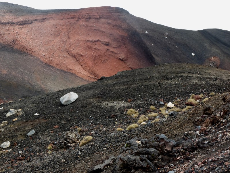
When the cloud lifted we were treated to some stunning volcanic landscapes as we descended along the edge of Red Crater (top). The steaming area called Emerald lakes below us (below). 
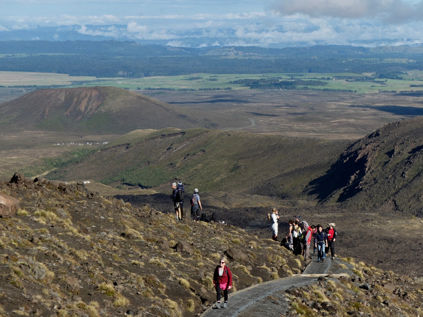
Ohakune was obviously not ‘the canary in the mine’ when it came to determining likely crowds on the mountain. At first we thought that we had been dropped at an All Blacks rugby test match venue but flailing walking poles, selfie sticks and back packs suggested we were at the start of the walk. Sign posts soon confirmed this, “Multiple Volcanic Hazards” “Stop! – are you fit enough? do you have the correct gear and clothing?”


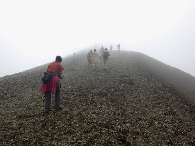
The bus had moved on before we could change our mind and return to Ohakune so we joined the ‘sherpa line’ that was heading into the clouds.
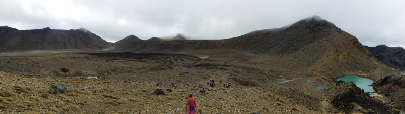
We never really lost the crowds and for long sections of the journey where the track was not suitable for overtaking, stopping to take pictures of the interesting fauna was not an option, you just had to ‘go with the flow’.
The weather was marginal. Ngaruahoe grudgingly appeared as we headed up the valley to our first climb up to the South Crater but by the time we hit the huge flat expanse of the crater all the mountain summits were surrounded by cloud. Our second climb was to Red Crater on Tongariro and we were in swirling cloud at around 6,000ft (1850m). Every now and then it would briefly lift to give us a glimpse of what we were missing.


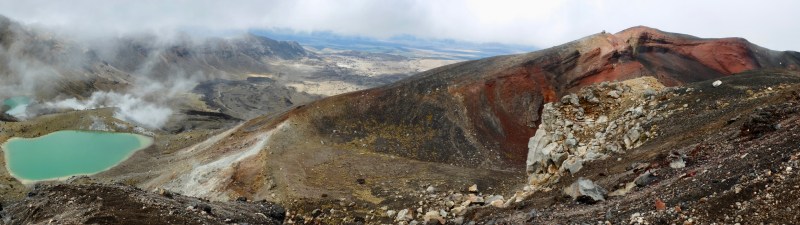
As we started the steep descent down the loose (and warm) scoria, the cloud suddenly lifted and gave us some majestic views of this still active crater and the Emerald Lakes. We have driven past Tongariro on many occasions but never realised the number and size of the many craters on this mountain alone.
By the time we started the long descent down the northern slope the cloud was again rolling in and this made it difficult to see the Te Maari crater which erupted in 2012. We could see the steam billowing from it but it tended to merge with the surrounding cloud.

As with all of our long walks (DDO’s) the last part is always the longest. The many steps and steepness of some of the climbs and descents had tested many of our muscles but we took comfort from the rest of the mob, most much younger than us, who all looked to be more than a little weary. Today (the dat after) is definitely a rest day.


The walk is stunning but the crowds and the need for speed do significantly detract from the experience. But then, if something is that good, it is always going to come with a crowd. There has to be a limit and I suspect the Tongariro Crossing is probably operating well outside what is good for both the area and the visitors.

Discover more from The Angel Tandem - Adventures on the wrong side of 60
Subscribe to get the latest posts sent to your email.

We never got the chance to do this epic hike when we visited New Zealand. So now we know what we missed – amazing, but possibly fleeting scenery; a pace that has to be adhered to; lots of other hikers for company. Looks like a memorable trek!
LikeLike
A lot more people than The Samaria Gorge, tougher on the legs but without the heat.
LikeLiked by 1 person